Student’s FURSCA Project Solves Puzzle for Map of Early Modern London
Related Programs

September 11, 2018
By Jake Weber

Senior Mackie Black, from The Woodlands, Texas, is majoring in English and anthropology, with a minor in history.
Scholars and researchers sometimes say that the process is as important as the discovery—but Mackie Black, ’19, who spent the summer untangling a 400-year-old map puzzle, says discovery is pretty darn satisfying.
The “mystery” started with Black’s goal to add an entry to the Map of Early Modern London (MoEML), an Internet-based project involving historians, literary scholars and anthropologists interested in 16th- to 18th-century London. Not surprisingly, the MoEML has information clusters around important landmarks, while other neighborhood histories are largely unknown.
Black was drawn to Petticoat (aka “Hog”) Lane, a street that in 17th-century London was known for its tanneries and leather works. “We know this street existed, but no one knew precisely where it was,” Black says. “There’s a lot of research done on Shakespeare, but I wanted a place where I could make a contribution, and this seemed like a good subject.”
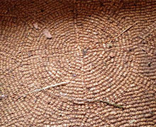
Detail of knuckle-bone floor. (Click here for source.)
The MoEML tentatively placed the street in Northeast London, but Black’s examination of other MoEML research did not support that idea. Working with both fiction and nonfiction references to Petticoat Lane and its proximity to better-known areas, Black’s research expanded from a computer spreadsheet to a “conspiracy wall,” where she arranged more and more 16th- and 17th-century street maps.
“I tied strings between places that I could use to triangulate the location of Petticoat Lane,” Black recalls. “Finding out where Petticoat Lane had been mentioned in the past, where it lies now, and proving this to the director of MoEML became somewhat of an obsession.”
A big clue came when Black found a 2006 anthropology doctoral thesis detailing the discovery of a “knuckle bone floor” in the area she suspected had been Petticoat Lane. “Tanners would save up the bones, break them in half and drive them into dirt to create a floor. Sometimes, they would create intricate patterns that rivaled the beauty of tile work,” Black explains.
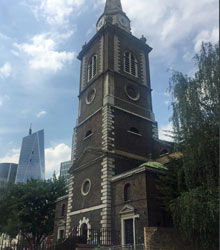
St. Botolph’s Without Aldgate. Photo by Mackie Black
London, of course, has changed a lot over the past 400 years, but Black says that supporting evidence can still be seen today. “I walked the historical Petticoat Lane, which today is called Middlesex Street,” she says of her research trip earlier this summer. “It dead-ends at Aldgate Avenue, which matches up to the historical Whitechapel Street. Down Aldgate Avenue, St. Botolph’s Without Aldgate matches up to the church that is present in all of the early modern maps that have Petticoat Lane listed. This tells me that Middlesex Street is indeed Petticoat Lane, which helps me to match up a modern map to the MoEML Agas Map and prove where Petticoat Lane should be.”
“I was walking the same road that was walked by the very people I have been researching,” Black concludes. “It really made me feel very small and yet at the same time important in being able to tell the stories of those who lived on that street so long ago.”
Black is the third Albion College student to contribute to the Map of Early Modern London; all of the students were supported by the College’s Foundation for Undergraduate Research, Scholarship and Creative Activity.